

Recci is short for reconnaissance (because we can’t spell it without spell check). As new members of the Macquarie Explorer Club, Angie and I volunteered to do a recci for a walk. Eventually, we also recruited Ivor to the task. This morning, we met up at the Lindfield Oval to scope out the Two Creek Track.
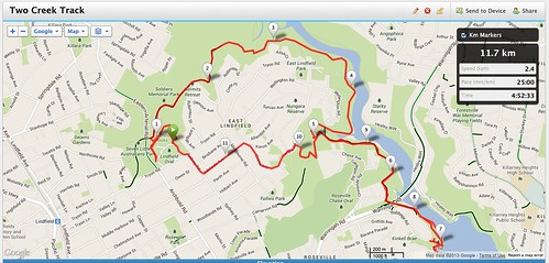 Two Creek Track with optional side trip to Echo Point |
I’ve been road testing my gears and was looking forward to this activity. I got my Samsung Tablet with Google Maps, MyGPS62 – GPS and electronic compass, my Forerunner 210 wrist watch to record my heart beat, cadence and the track. All these were pretty useless when we got lost. It was Angie’s map reading skills, and her patience to read the track notes lifted from her Sydney Walk book and other notes lifted off the internet that saved the day. All my gadgets gave absolutely no useful information.
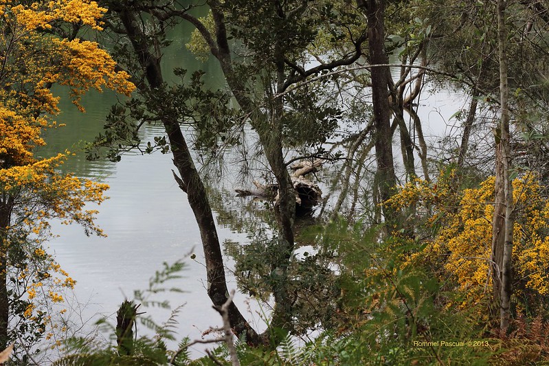
Filtered View of Moores Creek
We completed the track as mapped in the Sydney Walk book – including the optional side trip to the Echo Point in Roseville. There we stopped for lunch. The cafe had a peculiar sign on the menu – “We only Accept Cash or American Express”. That is so odd, I don’t even carry my Amex anymore because of so many businesses accepts all forms of payment except Amex. Ivor on the other hand, does not leave home without it. So pleased with the sign – he collected cash from us and use his Amex for the bill.
The track is very nice, some of it runs along a river. There are lots of birds, and since spring is upon us – the flowers are blooming. It is too nice that Angie started mocking our preparation for the Base Camp walk. She’s an Oxfam veteran – so I guess we can’t really shut her up.
I’ve also been trialing my equipment. Today – I was trialing my Deuter Futura 28 Daypack. It has an air-mesh back which was suppose to keep your back dry because it allows airflow between your back and the backpack. I don’t know if the designer intended to have the wind constantly blowing behind your neck. The movement of the backpack acts like a bellow and the small mesh just below the back of the neck is where the air escapes. It was very annoying. It is like being followed by someone with a straw and constantly blowing air at your back – and as soon as one stops – it stops. Eventually, however, I stopped noticing it.
Another is my Forerunner 210 Wrist Watch. This is the second time in so many walks that it stopped recording without me having to press the stop button. As a result I missed recording 2 km of the track as I didn’t notice it right away. In the Pindar Cave Bush Walk, it stopped recording after 2 hours and 25 minutes. The walk took 6 hours 25 minutes, thus the GPS recording is largely incomplete. The cadence wasn’t also recording which suggest problems between the foot pod and the watch. I also noticed that I have never had a successful cadence recording from this foot pod since I bought it in July this year. Until today, this is the first walk where the cadence were recorded in regular intervals, showing gaps only where we stopped.
I tried to take some photos. Angie, unfortunately, left her camera in her car and was too embarrassed to go back for it. Ivor was teasing her that she always forgets her camera – referring for when we climb down and up again to retrieve her camera in Wondabyne. As a result, she had all the time to hassle me when I took photos 🙂
|
Recent Comments